
Features
Heavy Equipment
Projects
Roads & Paving
Seeking solutions
Crews are investigating how to tackle 10 slide mitigation projects in B.C.'s Cariboo region.
February 12, 2024 By Grant Cameron
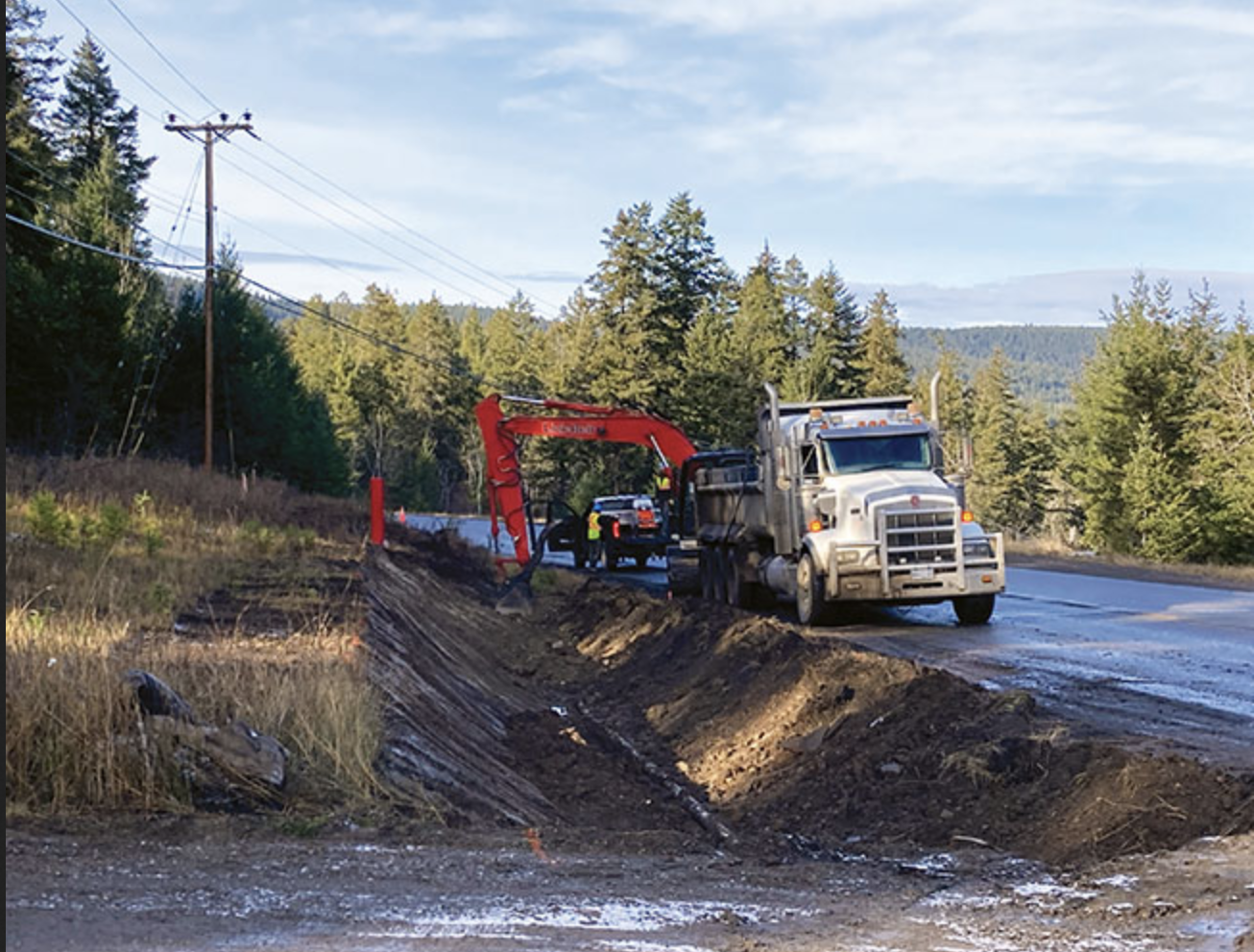
It’s late fall in the Cariboo Region of central B.C. Two operators have set up a drill rig near a stand of fir trees at the end of a dirt road close to Highway 20 at Hodgson and Dog Creek roads, southwest of Williams Lake.
Lengths of metal pipe are stacked nearby. One of the operators, in blue coveralls and a white hard hat, is at the controls of the heavy equipment. The other is a few feet away, keeping a watchful eye on the operation.
The area has been affected by a slow-moving landslide and the operators are there to do geotechnical drilling of up to 74 metres below the surface. Instruments will then be installed in the holes to measure the characteristics of the slide and provide engineers with the data they need to develop mitigation measures.
In 2021, multiple historic landslides were reactivated in the area. Sections of Highway 20 and portions of provincial side roads were damaged by the ground movement and were repaired. Since then, the Ministry of Transportation and Infrastructure has been investigating how to mitigate further slides in the area.
The venture is one of 10 slide mitigation projects along the Highway 97 corridor between Williams Lake and just north of Quesnel, known as the Cariboo Road Recovery Projects (CRRP). The work being done includes research on soil and water, environmental reviews and on-site inspections and interim drainage and slope improvements.
John Babineau, deputy director of the CRRP at the B.C. Ministry of Transportation, says drilling at the Hodgson and Dog Creek roads will provide engineers with the detailed information they need to come up with solutions.
“It’s a unique slide, it’s very large, it’s very deep-seated and is one that is particularly challenging,” he says. “The geotechnical investigation has been going on for the last two years. There was some additional investigation this fall to continue to inform the project team of the characterization of the slide.
“It allows us to get a good sense of what’s going on, what are the driving forces, how we could actually attack and try to stabilize the slide.”
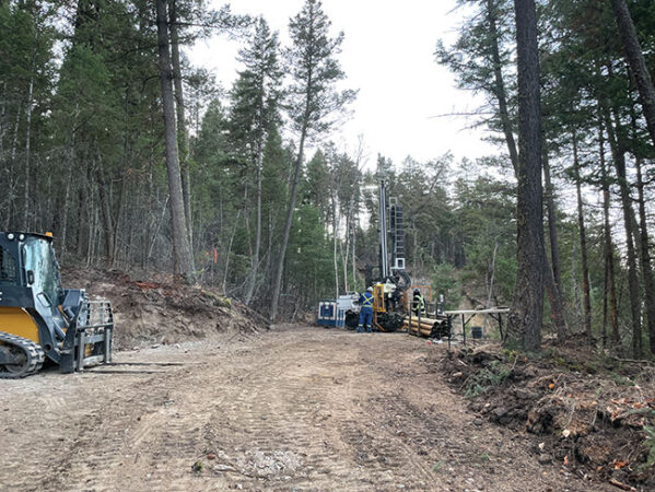
Geotechnical drilling crew at the Hodgson-Dog Creek roads slide near Highway 20.
Photo courtesy of B.C. Ministry of Transportation and Infrastructure.
The investigation will assess the amount of groundwater, gauge if movement has occurred and get a sense of where the failure plane is, how it’s changing over time and how the groundwater is interacting with the slide.
“We’ve learned you can’t have too much technical information,” says Babineau. “That level of investigation is a really important piece in making sure that when we deliver a solution, we’re confident it is the best solution. Our goal here is to slow down the slide and stop the slide if we can, and that will have a benefit to not just highway infrastructure but to municipal infrastructure, private utilities and homes as well.”
Work on mitigation options at the Hodgson and Dog Creek roads has been ongoing since spring 2021. The risk to public safety is considered low and roadways are still open. However, a potential fix is not easy.
Engineers will examine data that will be collected from instrumentation in the bore holes and look at information collected from past investigations. The details will provide the project team with a sense of forces driving the slow-moving slide and what measures need to be put in place to stop it from causing further damage.
“We know that surface water and groundwater are always problematic for landslides and managing that will always have a benefit to the slide, so we’ve undertaken ditching improvements, culvert improvements, moving standing water and surface water into public rights of way to get it into the ditches and get it down off the slide as efficiently as they can,” notes Babineau.
Indeed, crews have updated existing infrastructure and are clearing and widening ditches and installing a new culvert to move rain and snow melt from the upslope to downslope area.
The project team hopes to formulate specific options to stop the slide next year and present the measures to the public at meetings.
An idea for the Hodgson slide includes upgrading existing drainage infrastructure. On the Dog Creek slide, an option may include flattening the top of the slide, construction of a berm at the bottom to prevent movement, and placement of large rock in seepage areas. The slide is too big to stabilize mechanically.
Changing weather patterns have hit the Cariboo Region particularly hard in recent years. The province is restoring access where feasible while designing and building transportation infrastructure that will be more resilient.
In all, 10 sections of road in the Cariboo along the Highway 97 corridor between Williams Lake and just north of Quesnel were significantly affected and are slated for mitigation measures. Fixes for each area are different.
“We see some slides that are on major routes, and we’ve got some slides on very low volume sideroads,” says Babineau. “Some slides have been moving for a very long time but were certainly moving much more quickly in 2020 and 2021, and we have some that we’ve never known about before and have come out of nowhere.
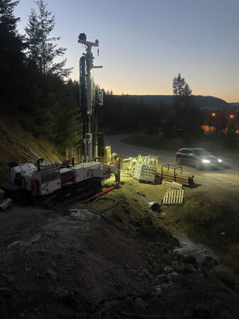
Geotechnical drilling work under way, at the Hodgson-Dog Creek roads slide near Highway 20. Photo courtesy of B.C. Ministry of Transportation and Infrastructure.
“Our approach on each of them, apart from using a thoughtful, technically-based approach, is that all projects are on their own path.”
The design and construction of two other projects along the route have been approved at a cost of $538 million. They are expected to move to the construction phase next year.
At Highway 97 and Cottonwood Hill, about 15 kilometres north of Quesnel, a historic slide reawakened in 2020 and ministry contractors have installed groynes along the Cottonwood River adjacent to the highway. The groynes, built with large rock material, redirect river flows away from the slide area.
Interim works have also reduced the force of the river on the bottom of the slide while the highway will be reconstructed and stabilized through the slide area. The stabilization work includes removing weight from the top of the slide and improving slope stability. Final details of the project are being confirmed and construction on the highway realignment is scheduled to start in the spring.
The project team is working with partners to ensure the protection of aquatic habitat and wildlife while working on the area.
At Blackwater and Knickerbocker roads, meanwhile, construction is expected to start in summer 2024, with installation of pumping wells to reduce groundwater pressure. Future phases of work will include the realignment of 1.4 kilometres of Blackwater Road, beginning in spring 2025, and armouring a section of the riverbank to withstand the river forces and ensure materials are held in place, starting in summer 2025.
This past summer, crews were doing environmental and geotechnical testing and research work at the site, including drilling to collect soil and water samples.
Seven more projects along the corridor are moving through the design and funding approvals stage and will require significant investment:
- Quesnel-Hixon Road: The road is closed to traffic as the slide remains active and unsafe for vehicles. Geotechnical investigations have been completed and crews did visual environmental inspections along Quesnel-Hixon Road, Cottonwood River Canyon Bridge and Cinema-Old/Ahbau Creek Bridge crossing locations, and Naver Creek.
- Quesnel-Hydraulic Road: The road is open to single-lane alternating traffic. In September, a geotechnical drilling program was carried out in the area to collect soil and water samples. A substantial amount of armouring and bank protection work was also done.
- Kersley-Dale Landing Road: A temporary, single-lane gravel road is open for local traffic and the ministry is in the final stage of determining long-term restoration options.
- Bastin Road at Bastin Hill: The road has been reduced to single-lane traffic. Construction work, including drainage improvements, slope repair and stabilization and debris removal was completed in 2022 and long-term restoration options are being explored.
- Durrell Road: The road is closed. Engineers are doing technical work and looking at restoration options.
- Highway 97 at Cuisson Creek: In 2021, cracked pavement and other surface damage was repaired and geotechnical drilling was done.
- Soda Creek-MacAlister Road: The road is closed at the slide area. A geotechnical drilling program was carried out and long-term restoration options are being explored.
While B.C. is always susceptible to landslides due to the mountainous terrain in many parts, persistent wet seasons in 2020 and 2021, combined with snow melts, triggered the deluge. Meanwhile, major wildfires damaged vegetation in the area, making it less effective at absorbing moisture and holding soil together.
“That really gave the groundwater a chance to saturate and come up into the slide and reactivate a number of slides,” says Babineau. “Since that we event, we haven’t seen that level of movement in the Cariboo Region.”
Each landslide is different and requires an individual fix, according to Babineau.
“They’ve all got their own characteristics. We see some slides that are on major routes, we’ve got some slides on very low-volume sideroads, some slides have been moving for a very long time, but were certainly moving much more quickly in 2020 and 2021, and we have some that we’ve never known about before and have come out of nowhere and had a really big impact on infrastructure.
“No two landslides are the same, nor is our approach on each of them.”
Print this page