
Features
Roads & Paving
Technology
Scanning the Bridge
Laser scanning reduces closures during Honoré Mercier Bridge reconstruction
July 30, 2015 By Carolyn Frith
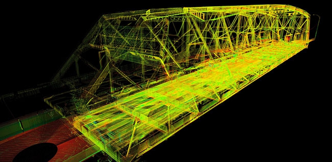 The laser scan produces a point cloud with millions of points of data.
 Connecting Montreal with Kahnawake, the Honoré Mercier Bridge extends almost one mile over the St. Lawrence River. It serves as a link between Montreal Island and the South Shore, and is the shortest route from Montreal to New York State in the United States. Not surprisingly, it’s one of the busiest bridges in Canada with an estimated 30 million vehicles crossing it each year.
Over the last eight decades, the bridge has evolved to meet increasing traffic demands. The original bridge opened in 1934 and accommodated two lanes of traffic. In 1963, another two-lane bridge was built downstream alongside it. The upstream bridge now is a conduit for traffic moving southbound from Montreal and the downstream bridge accommodates northbound traffic. The bridge is under two jurisdictions, the Ministère des Transports du Quebec (MTQ) and Jacques Cartier and Champlain Bridges Incorporated (JCCBI).
In 2008, after the bridge had borne 75 years of wear and tear, JCCBI initiated a multi-year rehabilitation project. In addition to strengthening the access ramps’ steel structure and concrete decks, the undertaking includes replacing the bridge’s deck. The bridge managers were concerned about how to minimize the closures of a main artery to Montreal as the deck was replaced. So, instead of pouring concrete on site, JCCBI engineers decided to use pre-fabricated concrete panels that can be produced indoors during the winter. They could then replace the decks in a blitz during the summer when traffic is lighter. This plan, however, brought with it the challenge of manufacturing the slabs so they would fit precisely. After all, once they entered into the concentrated time frame for the deck replacement, there would be no room for error and rework.
Sizing Bridge Deck Panels with Precision
To size the deck slabs, JCCBI hired a surveying company to take bridge measurements using total stations. Because of the need for accuracy within two to three millimeters, JCCBI decided to be abundantly cautious and have the dimensions double checked by Topo 3D, a construction surveying company. They did not realize Topo 3D would take an entirely different approach to bridge documentation – laser scanning.
“We already had expertise in supplying precise data for complex jobs in harsh environments with tight deadlines,” says Jonathan Bouffard, project director at Topo 3D. “So, it was up to us to determine the right tools to capture the required data. We chose to use our Leica ScanStation P20 and were able to take one hundred scans of the bridge per day. It was amazing to be able to scan a bridge that long in just a few days. And, of course, when we showed JCCBI management the results, they realized we had gone far beyond just verifying the initial data.”
The laser scanner enabled Topo 3D associates to sweep a laser beam over the bridge and attain detailed data. It produced a point cloud that represented millions of data points in three dimensions. Bouffard says they chose to use the Leica ScanStation P20 to record the data because of its ability to withstand extreme weather conditions while capturing data accurately, quickly and easily.
“Year after year, we put the Leica ScanStation P20 under severe conditions, and it is as reliable today as it was on day one,” Bouffard says. “The result is a scan with unprecedented clarity.” He adds that they not only captured the data at a fast pace, but also imported it, joined the point clouds from the multiple scans, and put the data through their quality control process.
The laser scan produces a point cloud with millions of points of data.


Measuring Movement
Prior to scanning the bridge, Bouffard knew there would be some challenges because its natural movements and vibrations would add a thickness to the measurements. To deal with this phenomenon, Topo 3D took multiple scans from different viewpoints, being cautious about overlapping data. The redundancy in documentation enabled engineers to check measurements in multiple ways, ensuring they were accurate. It also facilitated point cloud registration, the process by which engineers join the data from individual scans together. Where there were multiple points that reflected movement of bridge components, Topo 3D used software to determine the outer limits of the bridge’s movements. They then preserved the mid-point of the data and eliminated extraneous data points, creating more accurate information. This process, however, would not be possible with data produced by a total station because it takes punctual measurements, making it impossible to determine where a data point fits within the bridge’s movement.
Improving Time and Accuracy
If Topo 3D had used traditional surveying methods, the job would have taken much longer, and the deliverables would not have been as comprehensive. In addition to taking longer to capture the initial measurements, they would have needed to authenticate data after checking it for outliers – the data points that appear questionable because they stand out from the others. To validate data captured by a total station, engineers would have needed to revisit the bridge, increasing time required and costs. The laser scanned data, on the other hand, provided measurements within a point cloud that has a high level of redundancy. The point cloud enabled engineers to re-visit the bridge from the comfort of their offices, take measurements at multiple points, cross reference information, and definitively answer any questions raised.
Topo 3D provided JCCBI with an inspection report, measurements and images. They used Leica Cyclone software to create these deliverables along with other in-house programs, such as the one that helped clean up noise in the data caused by vibrations, dust and other residues. In areas where Topo 3D’s report noted measurements that were near or beyond tolerance limits, they could navigate through the point cloud with JCCBI’s engineers, showing their methodology and re-confirming their findings.
Virtual Testing
In addition to scanning the bridge, Topo 3D scanned the precast mold that was to be used to prefabricate the concrete slabs. They then tested it virtually against the 3D model and highlighted deviations to show where the mold’s dimensions were out of spec. WhileTopo 3D found that their predecessors’ measurements for the molds were mostly accurate, there were still discrepancies identified. This information enabled them to adjust the fabrication of the slab for a tighter fit. To confirm the correct locations and dimension for the stringers, as well as specifications for the anchors, Topo 3D ascertained the angles, parallelism and verticality of the bridge’s floor beams. This data could not be captured with a total station. They were, however, able to assess these elements because the point cloud data was in context and could be revisited to extract proper information. Had JCCBI moved forward based on the first company’s measurements, they would have needed to make adjustments on-site, would not have achieved as tight a fit, and would have lost valuable time. However, using Topo 3D’s data, they were able to avert these issues and predetermine where the stringers would attach to the beams.
Engineers at JCCBI are thrilled with what they’ve been able to accomplish using 3D laser scanning. “A phrase we hear a lot from clients,” says Bouffard, “is ‘if only I had known about this earlier.’ They realize the true potential of 3D data after seeing it. They are in awe when we show them our point clouds, and it’s inspiring to empower professionals with precise and relevant 3D data.” Now that JCCBI managers have seen firsthand the accuracy and efficiency of laser scanning, they have decided to use it exclusively for documentation of the downstream section of the bridge. They are confident that they will not need to do two surveys this time to validate data.
Carolyn Frith is a freelance writer based in Phoenixville, Pa.
Print this page