Products & Equipment
Roads & Bridges
GPS elevation control system in first paving application
Canada's first GPS paving project
July 24, 2008 By Andy Bateman
New Global Positioning System-based technology recently helped a paving contractor meet challenging elevation and smoothness specifications on a runway rehabilitation project.
Located near Belleville, Ont., the Mountain View detachment of Canadian Forces Base (CFB) Trenton was originally established in 1942 to train fighter and bomber pilots as part of the allied war effort. Sixty five-years later, Mountain View is again playing an important training role, with today’s programs designed for aircrews of heavy transport aircraft. As part of these programs, a runway section at Mountain View was recently rebuilt to exacting military standards, allowing pilots to hone their take off and landing skills before tackling more difficult airfield conditions elsewhere. For the runway paving contractor, those standards included a challenging combination of tight smoothness tolerances, precise surface elevations and a requirement to match the edge of the new paved surface with uneven surrounding surfaces. In a Canadian paving first, the contractor met those challenges using new GPS-based technology to accurately control mat elevation.
 |
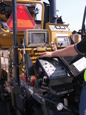
The Topcon System Five-3D Control Box
|
Grant Gabovic, project officer for the Department of National Defence, describes the background to the paving contract; "Lockheed C-130 Hercules and Boeing C-17 Globemaster III airlifters can be assigned anywhere in the world on military, medical, search & rescue or humanitarian missions. By the very nature of this work, pilots and aircrews of these medium and heavy lift cargo aircraft often face airfields which lack paved surfaces, space, landing lights, landing instrument systems or any of the above. In 2006, the Department of National Defence constructed a gravel landing strip at Mountain View for pilot practice on short and unpaved runways. This year, the rehabilitation of Runway 06-24 Right will give aircrews the opportunity to first practice on a smooth paved surface."
Brian McComb, construction manager for Lafarge Canada Inc.’s Eastern Canada Business Unit, explains that the rehabilitated area is 1.3 km long and generally 18.3 m wide, widening to 27.4 m in a 300 m long central section. Seen from above, it is entirely contained within the existing runway boundary. The scope of work included excavation, granular base and hot mix asphalt paving. Granular base specifications called for a minimum of 150 mm of Granular B Type II sub base followed by a geotextile layer and 150 mm of Granular A base material. Following base levelling and compaction, 5700 tonnes of the SP 19 Category E hot mix asphalt was laid to a compacted thickness of 60 mm.
Job specifications here presented a unique set of challenges to the runway builder, both in terms of smoothness and elevation. Smoothness specifications required that the finished asphalt surface must not have irregularities exceeding 5 mm when checked with a 4.5 m long straight edge placed in any direction. At the same time, the finished elevation of the runway centre line was specified to the millimetre, with a rider that the finished asphalt surface had to be within 5 mm of the design elevation but not uniformly high or low. Further, the edge of the new mat had to exactly match the surrounding unrehabilitated asphalt surface at all points of contact. With uneven asphalt surfaces of 1960’s vintage, the last requirement was particularly challenging as it would necessitate continual adjustment of the new mat’s crossfall slope during paving. To determine the required crossfalls, the elevation of the existing asphalt at the edge of the new area was measured at 20 m intervals along the runway on both sides of the centre line. The resulting crossfalls varied from 0.5 to 1.5 per cent and in some locations were of opposite sign with a negative slope on one side of the centre line and a positive slope on the other.
Given these challenges, the project provided a good opportunity to test the Topcon Millimetre GPS system in a paving application. For this particular job, a Topcon PZS-MC Machine Control Sensor and a System Five-3D Control Box were fitted to a conventional paver. During paving, the sensor used the signal from a Topcon PZL-1 Positioning Zone Laser to compute the required screed elevation. After paving, a hand-held GPS rover unit, fitted with PZS-1 Positioning Zone Sensor, HiPer+ wireless GPS+ receiver and FC-100 field controller, used the laser signal again to verify mat elevation at any point.
 |
|
Mat smoothness specifications required that the
|
Initial site work began with the removal of old asphalt and it soon became clear that the original runway foundation, a variable mixture of soil, clay and rubble fill, would also have to be replaced. As a result, excavation depths were increased to 1.0 m in places to reach bedrock, with excavated material recycled where possible for use elsewhere on site. Base material was graded and levelled into place with the millimetre GPS system, recognising that accurate base placement would be essential to achieve the tight asphalt specifications.
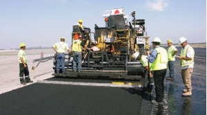
Apart from the new position control technology, the paving job was completed utilising fairly common production and paving practices. Hot mix asphalt was produced by a
 |
|
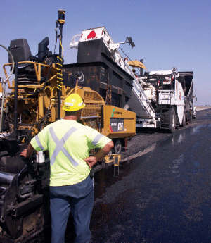
The site paving train included a Roadtec SB2500C
|
Barber-Greene 2.7-tonne capacity batch plant located in Belleville and delivered to site by truck. There, a Roadtec SB2500C Shuttle Buggy maintained a steady feed of material to a Caterpillar AP1055D paver. Behind the paver, the compaction train included Caterpillar CB-534C dual steel drum and PS-300B pneumatic compactors, together with a Ferguson 8-12B finishing roller. Immediately after mat placement, spot checks with the rover unit verified that the mat had been placed and compacted to the required elevation, while a straight edge provided ongoing smoothness checks. In those instances where the new mat was adjacent to an existing asphalt edge, the Topcon sonic averaging ski on the paver provided further input to the control system to ensure an elevation match. As a final check on the new pavement’s elevation, independent cross checks were completed by a conventional laser.
A Lafarge briefing paper on the demonstration project notes that the Topcon Auto Pave Millimetre GPS System provides stringless, 3-D paving control and a completely automated paving process and millimetre GPS vertical and horizontal screed positioning. The system can be installed on asphalt or concrete pavers and eliminates short-range robotic optical control systems. The system utilises the engineering digital site plan electronically and can be digitally updated wirelessly from the office with Topcon’s SiteLINK technology. The paper also referred to a recent study published in the Canadian Journal of Civil Engineering which showed that the GPS-based construction system can increase productivity by 21.74 per cent and cost savings by 12.92 per cent over the conventional system in a project with a short haul distance. GPS-based construction can increase productivity by 5.67 per cent and cost savings by 4.79 per cent in a project with a long haul distance.
Topcon literature explains that high precision, three-dimensional stakeless grading has been available for years. The disadvantage of these systems has been that an expensive specialised robotic total station is required for each piece of automated machinery. According to Topcon, the Millimetre GPS system now allows high precision control to be added to the com-pany’s existing 3D-GPS+ grade control system at much lower cost. The system’s "+" sign designation refers to use of multiple satellite constellations. In addition to the GPS satellite system it can draw on the Russian Glonas and future European Galileo constellation. In operation, precise elevation control is provided by a PZL-1 Positioning Zone Laser that projects a laser zone beam over a 300 m radius area. The unique signal of the PZL-1 is said to create a 10 m high zone of precision elevation control to facilitate vertical measurement in areas with large variations in elevation. Unlike expensive total station systems, the signal can be received by multiple machine or pole mounted positioning zone sensors. These laser zone sensors compute a precise elevation anywhere within the laser zone to provide instant millimetre accurate elevation control.
Geoshack Canada is an authorised dealer for Topcon in Ontario where 25 years of machine automation experience is said to provide a unique focus on positioning technology for construction, surveying and agriculture. In addition to three Ontario locations, Geoshack has fourteen U.S. locations and is billed as the largest machine control dealer in North America.
Print this page